Property Record
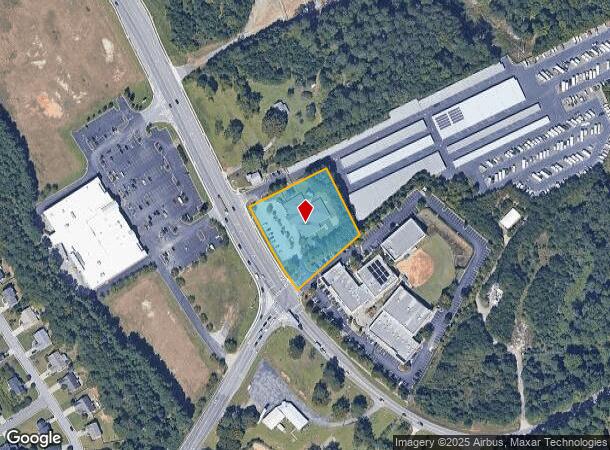
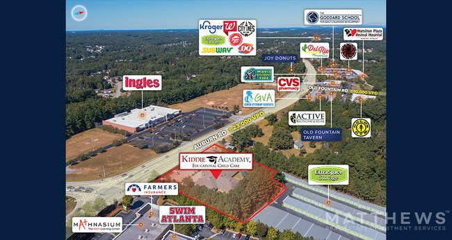
1162 Auburn Rd, Dacula, GA 30019
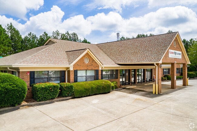

Property Detail
1162 Auburn Rd
2-001-425
GA HWY 324
Daycare
Gwinnett
X
Georgia
13135C0048G
1
2025
1.45 AC
2025
Suwanee/Buford
050619
Atlanta
9,966 SF
Atlanta-Sandy Springs-Roswell, GA
NEARBY LISTINGS FOR SALE OR LEASE
DEMOGRAPHICS near 1162 Auburn Rd
1 mile
3 mile
5 mile
2024 Total Population
8,613
53,769
127,540
2029 Population
8,960
56,489
135,545
Pop Growth 2024-2029
+ 4.03%
+ 5.06%
+ 6.28%
Average Age
38
38
38
2024 Total Households
2,642
16,437
39,826
HH Growth 2024-2029
+ 4.09%
+ 5.10%
+ 6.51%
Median Household Inc
$111,621
$109,839
$96,092
Avg Household Size
3.30
3.20
3.10
2024 Avg HH Vehicles
3.00
2.00
2.00
Median Home Value
$319,029
$330,491
$321,170
Median Year Built
2001
2003
2002
Nearby Places
Map Layers
Map Styles
 Street
 Aerial
Transit
 Traffic
 Biking
Places
Listings with unknown addresses are not visible on the map
- Restaurants
- Banks
- Shops
- Fitness
- Groceries
PUBLIC TRANSPORTATION
AIRPORT
Hartsfield - Jackson Atlanta International
Drive
Walk
Distance
Hartsfield - Jackson Atlanta International
63 min
49.1 mi
SALE & LEASE HISTORY
LISTING DATE
SALE/LEASE

Sep 16, 2024
For Sale
Oct 24, 2022
For Sale
Jan 06, 2023
For Sale
Dec 04, 2019
For Sale
Apr 16, 2019
For Sale
Nearby Properties
Address
Land Use
TOTAL SIZE
Lot Size
Zoning
Address
Land Use
TOTAL SIZE
Lot Size
Zoning
891.66 AC
R100
Address
Land Use
TOTAL SIZE
Lot Size
Zoning
403,129 SF
126.91 AC
RA200
Address
Land Use
TOTAL SIZE
Lot Size
Zoning
233,266 SF
17.39 AC
RA200
Address
Land Use
TOTAL SIZE
Lot Size
Zoning
250,960 SF
17.55 AC
OI
Address
Land Use
TOTAL SIZE
Lot Size
Zoning
101,343 SF
44.33 AC
R1400
Address
Land Use
TOTAL SIZE
Lot Size
Zoning
158,307 SF
26.77 AC
R75
Address
Land Use
TOTAL SIZE
Lot Size
Zoning
204,895 SF
26.89 AC
R1200
Address
Land Use
TOTAL SIZE
Lot Size
Zoning
149,440 SF
28.41 AC
M1
Address
Land Use
TOTAL SIZE
Lot Size
Zoning
134,673 SF
29.74 AC
RA200
Address
Land Use
TOTAL SIZE
Lot Size
Zoning
178,635 SF
28.77 AC
R1200
Address
Land Use
TOTAL SIZE
Lot Size
Zoning
138,229 SF
7.97 AC
OI
Address
Land Use
TOTAL SIZE
Lot Size
Zoning
23,126 SF
88.56 AC
RA200
Address
Land Use
TOTAL SIZE
Lot Size
Zoning
124,425 SF
20.73 AC
RA200
Address
Land Use
TOTAL SIZE
Lot Size
Zoning
160,446 SF
12 AC
GOV
Address
Land Use
TOTAL SIZE
Lot Size
Zoning
110,356 SF
20.42 AC
RA200
Address
Land Use
TOTAL SIZE
Lot Size
Zoning
97,824 SF
13.71 AC
M1
Address
Land Use
TOTAL SIZE
Lot Size
Zoning
61,686 SF
10 AC
R1400
Address
Land Use
TOTAL SIZE
Lot Size
Zoning
93,702 SF
5.66 AC
C2
Address
Land Use
TOTAL SIZE
Lot Size
Zoning
102,618 SF
18 AC
R1200
Address
Land Use
TOTAL SIZE
Lot Size
Zoning
4,588 SF
109.24 AC
RZT
Address
Land Use
TOTAL SIZE
Lot Size
Zoning
99,516 SF
10.83 AC
C3
Address
Land Use
TOTAL SIZE
Lot Size
Zoning
84,890 SF
20.02 AC
RA200
Address
Land Use
TOTAL SIZE
Lot Size
Zoning
73.79 AC
RZT
Address
Land Use
TOTAL SIZE
Lot Size
Zoning
41,757 SF
19.66 AC
RA200
Address
Land Use
TOTAL SIZE
Lot Size
Zoning
117,207 SF
12.97 AC
C2
Address
Land Use
TOTAL SIZE
Lot Size
Zoning
89,487 SF
11.15 AC
C2
Address
Land Use
TOTAL SIZE
Lot Size
Zoning
91,115 SF
5.20 AC
C2
Address
Land Use
TOTAL SIZE
Lot Size
Zoning
80,429 SF
9.67 AC
C2
Address
Land Use
TOTAL SIZE
Lot Size
Zoning
78,086 SF
7.17 AC
C2
Address
Land Use
TOTAL SIZE
Lot Size
Zoning
69,901 SF
10.01 AC
C2
The World's #1 Commercial Real Estate Marketplace
Connect with us
© 2026 CoStar Group
The information above has been obtained from sources believed reliable. While we do not doubt its accuracy we have not verified it and make no guarantee, warranty or representation about it. It is your responsibility to independently confirm its accuracy and completeness. Any projections, opinions, assumptions, or estimates used are for example only and do not represent the current or future performance of the property. The value of this transaction to you depends on tax and other factors which should be evaluated by your tax, financial, and legal advisors. You and your advisors should conduct a careful, independent investigation of the property to determine to your satisfaction the suitability of the property for your needs.